Top 10 weird and strange places where people live – Life Improving the guide. Human civilization can adapt and thrive in the most unexpected corners of the world. From remote islands to extreme climates, there are places people have chosen to call home that may seem downright strange to the average person. These strange habitats offer a glimpse into the diversity of human resilience and ingenuity.
An exhibition of the remarkable ways in which humans have established their existence in the most unconventional environments. Across the globe and in the nooks and crannies of the world lie communities that inhabit some of the most bizarre and extraordinary places imaginable. From underground cities carved out of rock to floating islands made out of reeds, these unique homes showcase the remarkable adaptability some people have.
Table of Contents
Here Are The 10 Weird And Strange Places Where People Live
10: Comoros Islands
Comoros Islands is an archipelago nation in Southeastern Africa. It sits at the northern tip of the Mozambique Channel in the Indian Ocean. Moroni, the largest city, serves as both the capital and the heartbeat of the country. Since declaring independence from France on July 6th, 1975, Comoros has been navigating its unique position as the sole Arab League member in the southern hemisphere.
As part of the African Union, the Comoros boasts a diverse cultural landscape with three official languages: Shikomori, French, and Arabic. Despite being the third smallest African country by area at 1,659 square km, Comoros faces challenges driven by its high population density. In the most densely populated agricultural zones, numbers can reach up to a thousand people per square kilometer, posing potential environmental threats.
Especially considering the country’s primarily rural and agricultural economy. But here’s the kicker: with approximately 850,000 people, Comoros stands as one of the world’s least-populated countries. Yet its population density is significant, averaging 275 individuals per square kilometer. Rapid population growth, particularly among the youth, creates a demographic complexity, with almost half of the population under the age of 15.
Urbanization is on the rise, with major centers like Moroni, Moutsamudu, and Mitsamiouli shaping the country’s landscape. Interestingly, a considerable Comoran diaspora, numbering between 200,000 and 350,000 individuals, has found a home in France, underscoring the global reach of this small yet distinct nation.
09: The Pitcairn Islands
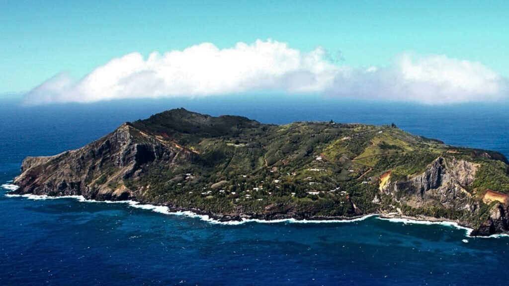
The Pitcairn Islands, a remote group of volcanic islands in the Southern Pacific Ocean, constitute the exclusive British Overseas Territory in that region. Consisting of four islands—Pitcairn, Henderson, Ducie, and Oeno—these scattered landmasses cover around 46 square km in total. It’s not much; despite Henderson Island dominating the land area at 86% of it, only Pitcairn Island is inhabited.
The closest neighbors are an island in French Polynesia, located 688 km to the west, and Easter Island, situated about 2,000 km to the east. The Pitcairn Islanders, a biracial ethnic group traced to primarily nine Bounty mutineers and a few Tahitian consorts, evident in many Islanders’ surnames. The infamous Bounty Mutiny and its aftermath have captured attention in various books and films.
As of January 2020, the territory had a mere 47 permanent residents, marking a significant population decline since 1940. Recognizing the importance of long-term sustainability, the island community acknowledges that repopulation is its primary strategic development objective. The demographic challenge, the government is actively trying to attract immigrants to the island.
The impact of the population decline is evident, with only two births on Pitcairn in the last two decades leading up to 2012. Nevertheless, some Pitcairn mothers sought increased healthcare safeguards by traveling to New Zealand for pregnancy and childbirth. In a historic milestone, in 2005, Shirley and Simon Young became the first married outsider couple to secure citizenship on Pitcairn.
As of April 2021, the resident population remains at 47, though it’s uncommon for all residents to be on the island simultaneously due to various reasons such as family visits, medical needs, or attendance at international conferences.
08: Supai Village
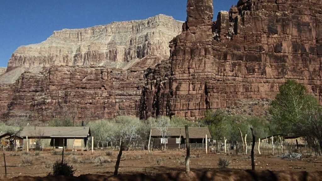
Supai, also known as U and Havasupai, stands as a census-designated place within the Grand Canyon in Coconino County, Arizona, in the United States. This unique settlement, as of the 2010 census, had a population of 208 residents. The area is characterized by its exceptional remoteness and can only be accessed by helicopter, on foot, or by mule. Located 12 km from the nearest road.
Supai holds the distinction of being the most remote community in the contiguous United States, according to the US Department of Agriculture. Mail delivery in Supai is particularly distinctive as it’s the sole place in the United States where mail is transported in and out exclusively by mules. Perishable goods dating back to 1989 are stored in a refrigerator in Peach Springs, Arizona, before being loaded onto mules for transport.
Supai did face a significant flood in 1910 that impacted the town. In the 1960s, Martin Goodfriend, a tourist advocate for the Supai people, countering the perception of Supai as a mythical Shangri-La, a columnist for the Arizona Republic, shed light on Goodfriend’s efforts through articles. The community experienced evacuation in August of 2008 due to the flooding of Havasu Creek and the failure of the Redlands Dam after heavy rainfall.
Evacuees were transported to Peach Springs, Arizona, and subsequent flood events in 2010 and 2018 caused severe damage to trails, bridges, and campgrounds. Flash flooding in July of 2018 resulted in the helicopter evacuation of 200 visitors. Tourism was suspended from March 2020 to February of 2023 due to the COVID-19 pandemic. To access Supai, one has to embark on an 8-mile hike, descending over 2,000 ft in elevation from Hualapai Hilltop through the picturesque Walapai Canyon. This challenging journey offers a direct and immersive experience of the surrounding landscape.
Read More: 10 Animals That Were Scarier Than Dinosaurs
07: Tempest Town
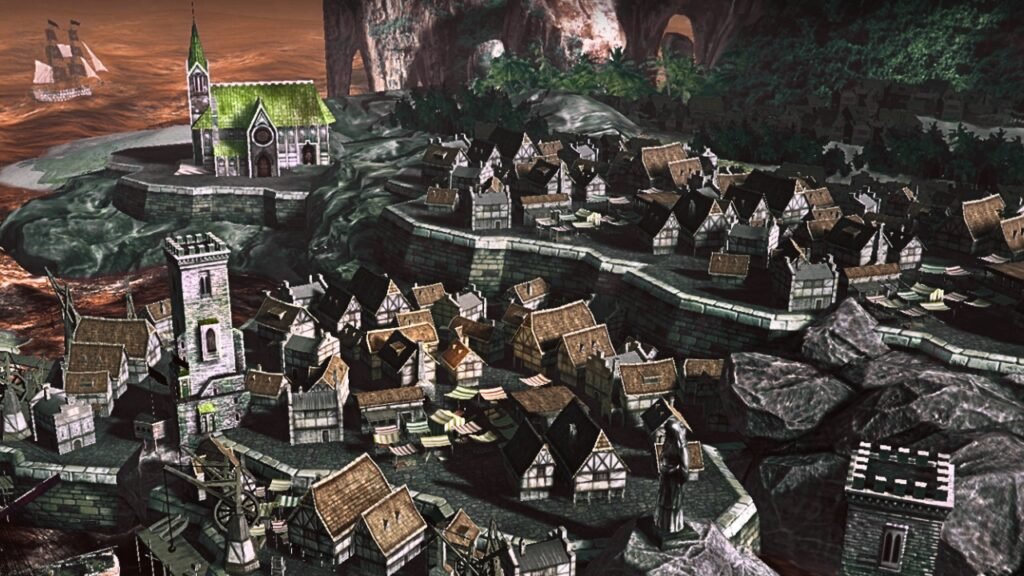
So, Tempest Town, nestled approximately 30 km from Central Shanghai in the Shang Jong district, is a peculiar destination. This new town, named after the River Thames in London, United Kingdom, is a whimsical attempt at replicating British market town styles. Cobbled streets, Victorian terraces, corner shops, and iconic red telephone boxes transport visitors to an unusual fusion of English charm in the heart of China.
Commissioned as part of the One City Nine Towns initiative in 2001, Tempest Toown was designed by the architectural firm Atkins and completed in 2006. It spans an area of less than half a square mile to accommodate over 10,000 residents. However, the reality turned out quite differently. High house prices deterred permanent residence, leading to an unexpected consequence.
Tempest Toown became known as a ghost town. While the houses sold swiftly, most buyers were relatively affluent, acquiring properties as investments or second homes. The town’s architectural mimicry extends to direct copies of English buildings, including a church modeled after Christ Church in Bristol, a pub, a fish and chip shop, and even Chester High Cross, replicating structures found in Dorset.
The construction cost amounted to about 5 billion W. Tempest Toown’s character is one of low-density single-family housing with limited commercial and community facilities. It’s a unique blend of British aesthetics viewed through a unique lens that’s been described as a “grotesque and extremely funny parody of an Old English town” by Jonathan Glancy. Well, despite that emptiness and the term “virtual ghost town” used by Business Insider.
Tempest Town continues to attract attention as a backdrop for wedding photography. The juxtaposition of its replicated English charm against its deserted reality renders Tempest Toown an oddity, offering a surreal experience for those who venture into this unconventional urban environment.
06: Longyear Ballard Town
Longyear, bin dubbed the Longyear town, holds the unique distinction of being the world’s northernmost settlement with a population exceeding a thousand people. It’s situated on the Left Bank of the Longe Valley and along the shores of the Advent fan. The town is nestled in Spalart, Norway, making it the largest inhabited area of this archipelago. Longan stretches along the picturesque Estuary leading into Isen on the west coast of Spitzbergen, the broadest Inlet on the island.
Originally, it was named Longe City until 1926. It is a remote village that is owned by the American John Monroe Langer, who founded it in 1906. His Arctic Coal Company initiated coal mining operations, marking the town’s genesis, and later, in 1916, Store Norsk Pittsburg and K company assumed control of mining activities, a role it still plays today. Longer ban faced significant challenges during World War II when the German Saxe Marina almost wiped out the city in 1943.
However, resilient efforts led to postwar reconstruction. Now historically, it was a company Town. Long you be an experience to shift in the 1990s as most mining operations relocated to Sgrua. By 2017, SNSK ceased gold Production due to substantial Financial losses incurred in 2014, prompted by adverse market conditions. Home to institutions like the University Center in Spard, the Global Seed Vault, and the Spard satellite station, Long Yan became a hub for scientific exploration.
Practical measures in this remote Town include unique laws seldom seen elsewhere. Regulations include a ban on cats, restrictions on monthly alcohol purchases, and a mandate for individuals venturing outside to carry a rifle for polar bear protection. An intriguing anecdote surrounds the claim that it is, quote-unquote, illegal to die in the Longe bin. While not strictly true, the town faces a peculiar situation stemming from a 1950 decision.
Bodies buried in the permafrost during the 1918 flu pandemic discovered remarkably preserved spark concerns about live strains of the virus. Consequently, residents deemed terminally ill are often required to relocate to the mainland due to the ban on local burials. This particular aspect of Long Urban is influenced by historical influences and economic changes, and its extreme environmental challenges make it a fascinating and unique destination in the remote Arctic.
05: Western Australia Pilbara Town
What Nom an only recently abandoned Town located about 14,400 kilometers north-northeast of Perth in the Pilbara region of Western Australia stands as a haunting Testament to the devastating consequences of asbestos mining. The town was established in the 1940s as a company town for blue asbestos mining, which became a lucrative industry in the mid-20th Wh no’s rise to prominence came during the 1950s.
When it became Pilbara’s largest town, with a peak population of 8 81 residents recorded in the 1961 census. The town supplied Australia’s only source of blue asbestos during this period; however, its prosperity was short-lived as health concerns surrounding his best mining grew, leading to the closure of the mine in 1966. By the early 2000s, the town had been declared a contaminated site comprising 50,000 hectares and earning.
The dubious distinction of being the largest contaminated site in the southern hemisphere. The town’s official status was revoked by the government of Western Australia in December 2006, leading to the removal of its name from maps and road signs. The process of De-gazetting the town site was officially completed in 2007. The Whitnum Steering Committee convened in April 2013 to finalize the closure of the Town and restrict access to the area.
And raise awareness of the risks associated with his best side exposure. As of 2016, Whitnum defiantly hosted three permanent residents who resisted the government’s plans to remove services and demolish the town. However, by September 2022, the last remaining resident was evicted, marking the end of habitation in this hazardous location. A report in November of 2006 by Consultants highlighted.
Extreme danger from asbestos contamination in Wat Phnom and surrounding areas. The risks were categorized as medium for visitors and extreme for residents. In response to these findings, the Western Australian government commenced the demolition of the remaining structures in May of 2023, sealing the fate of Whit Noom as a cautionary tale of the disastrous consequences of an unchecked industrial process.
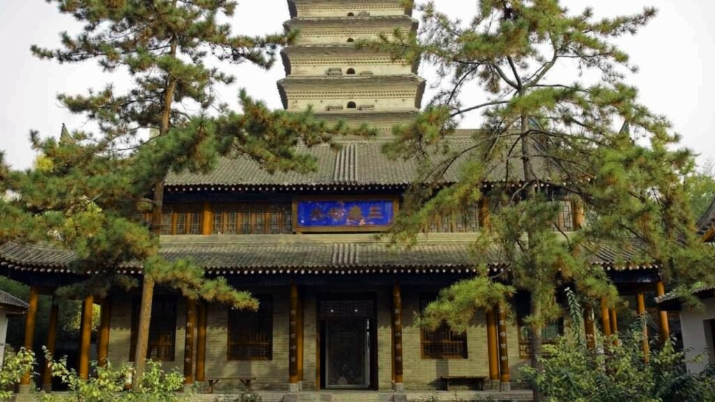
04: Shibam Yemen Town
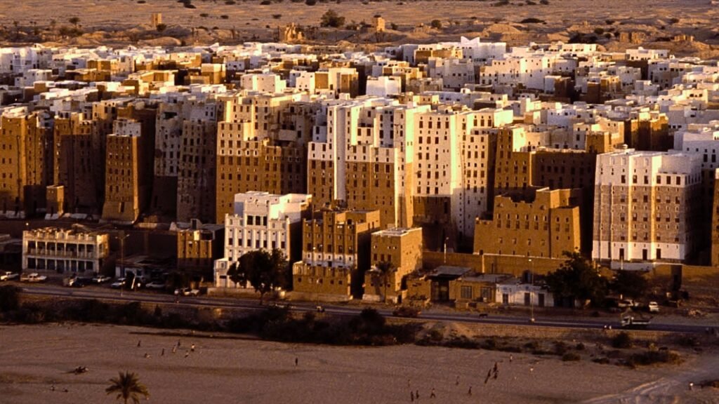
Nestled in Yemen, Shibam Hadrat emerges as a town of unparalleled architectural Wonder distinguished by its mud-bricked high-rise buildings that have earned it the captivating title of the Manhattan of the desert. Housing approximately 7,000 residents, Shibam serves as the Hub of the District of Shibam within the government of Hadrat. This ancient town has a hot desert climate where June, with an average temperature of 82° Fahrenheit, stands.
The hottest month while January is the coldest, with temperatures averaging 65°. Shom’s distinct architecture, primarily constructed from mud brick, has garnered it recognition as a UNESCO World Heritage Site. The houses of Shibam, numbering around 500 tower blocks, rise impressively between 5 to 11 stories high, with each floor housing one or two rooms. It is often recognized as the oldest skyscraper in the world.
Shabam stands as an exceptional example of urban planning based on vertical Construction principles. The city has some of the tallest mud buildings globally, with structures exceeding 100 ft, akin to early high-rise apartment buildings. Encircled by a protective fortified wall, Shabam is aptly known as the Walled City of Shabam, adding another layer to its Mystique. However, the architectural wonders of Shabam.
Faced with constant threats from wind, rain, and heat erosion, these mud brick buildings require constant maintenance to maintain their integrity. The town did experience significant changes in 2008 when flooding from a tropical storm compromised the foundations of many structures, leading to their collapse. But despite those challenges, Shibam remains an enduring Testament to human Ingenuity and resilience, capturing the imagination of all who encounter its ancient Skyline.
03: The Floating Village of Benin
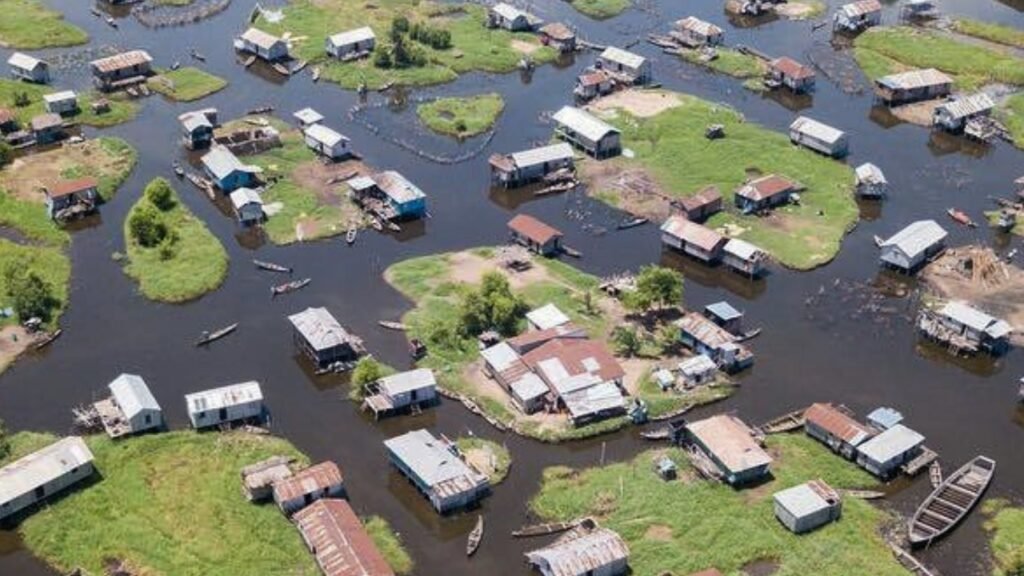
In the annals of colonial Brazil, a unique narrative unfolded as runaway slaves and free natives sought Refuge deep within the Amazon to escape the harsh grip of Portuguese slavery. Amidst dense vegetation, intricate waterways, and The Perils of Wildlife and disease, these communities found solace well hidden from the Relentless pursuit of slave Traders.
During this, in another corner of the world near Benin. A small group of people crafted a remarkable Haven against Portuguese capture. The powerful West African Fwn tribe engaged in hunting and selling other native tribes to the Portuguese, inadvertently playing a role in The Genesis of Gvi village located on Lake Noay.
Gve is a stilt village home to about 20,000 people. Its Origins Trace back to the ancestors who sought refuge on the water to elude the Fawn Warriors. Over approximately 500 years, Gany has cultivated a rich and thriving culture, adapting to the challenges and opportunities presented by life on a lake.
The distinctive feature of Gvi is its unique architecture, with only a school Standing On Solid Ground among its 3,000 buildings. Even a cemetery Mound under construction will exist on water. The villagers navigate their aquatic World almost exclusively by boat. Domesticated land animals are a rarity here, confined to patches of grass emerging from the water.
The absence of traditional livestock depends on a complex network of underwater fencing to the coral. And cultivates a diverse fish population, showcasing the village’s resources. Located several kilometers from the nearest Shoreline, Ganv is a 4-hour boat Journey from the capital, making it Africa’s largest Lake Village. The legacy of Ganv is a testament to the resilience and Ingenuity of a community that turned adversity into an opportunity to thrive amidst the Serene Waters of the lake.
02: Tandu Chang Town In China
Tandu Chang, located in the Hungo district off the east coast of China, stands as a fascinating experiment in real estate development, offering a glimpse into a peculiar blend of European charm and Chinese ingenuity. Born around 2007, It was designed to be a Paris-themed gated community. To accommodate about 10,000 residents, emulating the allure of the French capital. However, the reality deviated significantly.
And Tandu Chang is now home to only a fraction of its intended population, a modest 2,000 inhabitants. The main challenge to its Allure is its geographical placement. Positioned 40 minutes away from Hung’s bustling downtown and surrounded by farmlands, the Allure of a Parisian experience seems to have fallen short of expectations, resulting in a community that evokes an eerie atmosphere rather than a romantic vibrancy.
To enhance the illusion of a European Escape, Tandu Chang boasts a series of architectural replicas, including a towering 300t Eiffel Tower, offering an elegant Syrian offering of imitation Parisian restaurants, a Chapel of Love caters to couples looking for faux-luxe photo opportunities, and a Chateau sits atop a hill. The Surreal experience continues as visitors explore the Shanzi L, encountering an unsettling absence of foot traffic.
This place appears Frozen in Time, with stone busts of poets repurposed for practical use, serving as places for Pang laundry. A fake storefront with misspelled cursive writing and faded paint contributes to the overall sense of abandonment. Intricate statues of horses stand juxtaposed with women selling cotton candy, adding to The Surreal atmosphere of what can only be described as a bizarre Paris.
A hauntingly empty replica of the city of love. In the end, Tandu Chang presents a funky little Paradox, a place where you can be physically present, yet The Emptiness and haunting Ambiance might leave you feeling as if you’re in two places at once, experiencing a distorted version of the romanticized Parisian dream.
01: Miyakejima Island In Japan
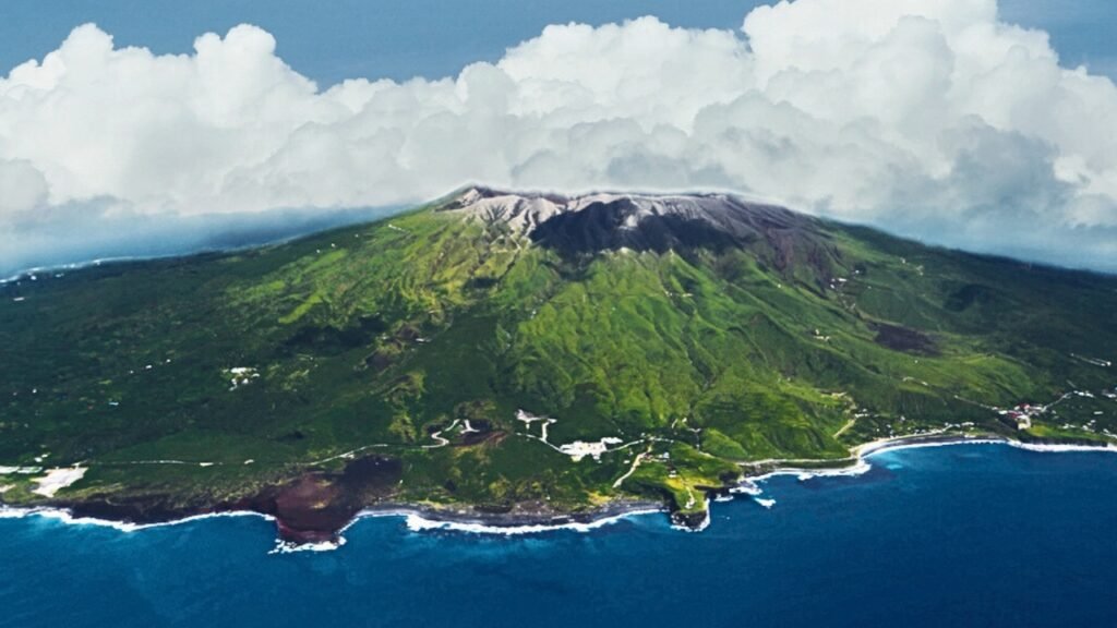
In the remote reaches of Japan’s Izu Islands lies Miyakejima, a place where the natural elements take center stage in a unique and at times hazardous performance. Perched atop an active volcanic chain that has erupted six times in the last century, the Akiima isn’t just grappling with the threat of volcanic eruptions; it contends with the highest concentrations of poisonous gases, primarily sulfur, constantly wafting up through the Earth.
This island, characterized by a composite cone formed in the late Pine period, carries an intriguing geological history with a circular Coastline spanning 88 km and an average diameter of about 8 km. Its towering Peak, Mount Oyama, stands as the Island’s Crown, reaching a height of 759 M. Over the past 890 years, this active volcano has erupted 13 times, etching its presence into the historical records as far back as the Nara period.
In the summer of 2000, Mount Oyama unleashed another series of eruptions, leading to the complete evacuation of Miyakejima by September. Although the need for masks has since diminished, alarms serve as Vigilant Sentinels, echoing warnings if toxic gas levels surge. Continuous monitoring, facilitated by a multi-component gas analyzing system, enhances the prediction of volcanic activity by detecting pre-eruptive degassing or rising magma.
Now, amidst this surreal, almost post-apocalyptic landscape, Miyakejima remains open to Intrepid tourists. Beyond the ominous veil of poison gas, pockets of lush Beauty adorn the island, creating a striking contrast for those who dare to embrace the juxtaposition of danger and allure. Gas masks await at various tourist shops upon arrival. Flights connecting Miyakejima Airport and Haneda Airport offer a relatively quick Journey spanning about 50 minutes.
Providing a glimpse into the island’s unique character. Yet the island’s accessibility comes with a caveat: the volatile nature of the region, characterized by a high volume of sulfuric gas, has left its mark on Transportation. Following the eruption of Mount Oyama on July 14th, 2000, a relentless flow of toxic gases rendered the air unsafe for travel. Consequently, flights were abruptly suspended, leaving the airspace above Miyakejima vacant for nearly 8 years.